Did Apollo traverse planning and surface operations facilitate accurate geologic interpretations of the lunar surface? Researchers tried to determine the validity of the Apollo-style approach to surface exploration from a geology perspective. As we cannot revisit the sites explored by Apollo astronauts to address this question, they instead turned to an analog test (Desert-RATS) in the Arizona desert that was planned and executed in an approach similar to the last three Apollo “J” missions. The first, already-published ‘orbital’ map was used to plan the Desert-RATS traverses, then the other two maps were generated independently from one another, in two teams, to compare the geology interpreted from the Apollo-style traverses (Lab Team) to that interpreted from traditional field mapping (Field Team). They found that the Apollo approach was very effective for characterizing local geology, and that future surface exploration missions should maximize astronaut access to the field site to facilitate accurate interpretations of local geology.
The results also confirmed that investigating local geology with “boots on the ground” and “noses to the outcrops” substantially increases our understanding of local geology.
All three resulting maps showed generally the same geology, but those produced from field work data showed more discoveries that were below the map scale and not visible from overhead images. The best understanding of site geology came from integrating pre-mission data, post-mission lab data and field observations into a single product.
The analysis also showed that there is an optimal field work duration after which gaining new knowledge slows down considerably.
The results of the experiment were presented at the 2015 AGU Fall Meeting in San Francisco, CA.
Source: Epper D, Bleacher J, Evans C, Greuner J, Hurwitz D, Janoiko B, Skinner J, Whitson P (2015) Field checking Apollo: comparing geologic datasets collected by planetary analog traverses and by standard geologic mapping – implications for planetary exploration and planning. AGU Fall Meeting, San Francisco.
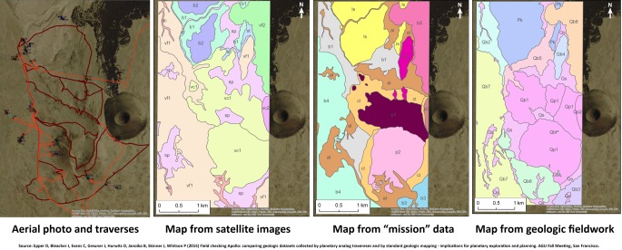
Figure:
a) Aerial/Orbital photomap, Apollo analog and standard field traverses
b) Map produced from orbital/aerial images
c) Map produced from data collected in a simulated astronaut expedition (post-mission images, videos, crew field notes and returned samples)
d) Map produced using standard terrestrial field geologic mapping techniques